Funded by the Andrew W. Mellon Foundation, the Spatial Humanities Initiative Lecture Series highights the research of scholars who are interested in space but also exploit a vast assortment of information technologies; explore, critique, and experience the modeling and mapping of historic sites and events; and together incubate a multi-disciplinary and broadly humanistic collaboration among interested tech innovators, faculty, and students.
2018-2019 |
|||
|
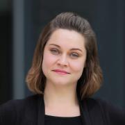
Hypespace: The Visual Culture of Retail ArchitectureMarch 21, 2019 | 4:00pm | Herring Hall 308 Considered sites of public display and consumption, the department store emerged in tandem with a deluge of art museums in Europe and America during the mid-19th century. No longer reserved for the elite class, these two typologies flattened social hierarchies and democratized aesthetics for a wider public. A strong parallel can be made between this historical moment and the current phenomenon of participatory installations and pop-up retail experiences mediated through social media platforms. While the exhibitionary system of museums informed methods of retail display for many years, the consumption of limited-edition collaborative releases and life-style driven brands has manifested a hyper-selective public with discriminative taste and consequently perpetuated an institutional shift. This research considers how technology and visual culture have (re)shaped sites of public consumption through the creation of an evolved consumer—the collector of exclusive goods and experiences—and how architects, curators, designers and retailers translate this ephemeral infatuation with “newness” in the real time space of museums and stores. Courtney Coffman is Manager of Lectures and Publications at Princeton University's School of Architecture.
|
||
|
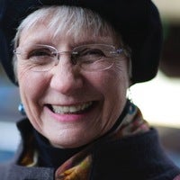
A Middle Green: Wallace Stevens and the American Park MovementJanuary 24, 2019 | 4:00pm | Humanities Building 118 "Everything in nature is artificial and everything artificial is natural." So wrote Wallace Stevens in 1950 after one of his habitual strolls through Elizabeth Park in Hartford, CT, where he imagined the roses were “placed . . . daily by some lover of mankind.” Throughout his poetic career, Stevens presents parks as both organic environments evocative of nature and as spatial works of art designed for inclusion in an urban habitat. Stevens’ life-long poetic engagement with the American Park Movement explores the aesthetic, social, and organic life of some of our most iconic public green spaces. This presentation will explore how his park poetics celebrates the use of nature as aesthetic media, thereby denaturalizing these urban green worlds, while it also critiques the often failed civic ideals embedded in these works of public architecture. Julia Daniel is an assistant professor of English at Baylor University.
|
||
|
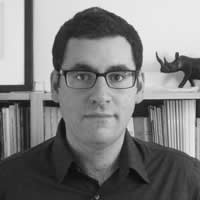
The Matter of the Neighbor: Budd Schulberg, James Baldwin, and the Watts Writers WorkshopOctober 11, 2018 | 4:00pm | Humanities Building 118 This talk explores the Watts Writers Workshop, founded in the heart of Watts by Jewish American writer Budd Schulberg immediately after the Watts Rebellion of 1965, and argues that the success and final demise of the project tracks Schulberg’s shift from prose to property. Drawing on Schulberg’s archives, including lease contracts, letters, and personal notes, I argue that Schulberg’s personal and financial investment in Watts re-located his political standing as the “neighbor” to the Watts writers with whom he worked. The catch is that being a neighbor subjected Schulberg to political marginality and police harassment, culminating in the FBI sabotage of the Workshop (it was burned down by an admitted FBI plant in 1973). Schulberg never fully understood his outsider-insider status, a claim he substantiates through a careful reading of a conversation between Schulberg and James Baldwin, where Baldwin is able to peel back the multiple layers of identity sustaining whiteness’s controlling claims on black property, thereby recalibrating what “Jewish” and “black” meant to each other in Watts and beyond. Dean Franco is a professor of English at Wake Forrest University. |
||
2017-2018 |
|||
|
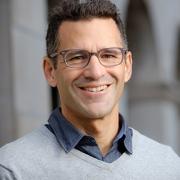
Data, the Campus, and the City: Diachronic Mapping and HoustonMay 1, 2018 | 4:00pm | Moody Center for the Arts, Double Studio Classroom This presentation will introduce the project "Waterways + Highways," recently funded by the Rice Houston Engagement and Recovery Effort (Rice HERE) and launch the project "instituteRice." Both projects consist of online mapping platforms that illustrate the evolution of the city and the campus, respectively, as they existed as well as they have often been imagined. Farès el-Dahdah is Professor of the Humanities and Director of the Humanities Research Center at Rice University. |
||
|
The Shakespeare and Company Project: Recreating the World of the Lost GenerationApril 26, 2018 | 4:00pm | Moody Center for the Arts, 201 In 1919, an American named Sylvia Beach opened an English-language bookshop and lending library in Paris. She called it Shakespeare and Company, and it soon became the meeting place of a community of expatriate writers and artists that included Gertrude Stein, Ernest Hemingway, and James Joyce. In 1922, Beach published Joyce’s Ulysses under the Shakespeare and Company imprint -- a feat that would assure the bookshop and lending library’s iconic status. The Shakespeare and Company Project is a digital humanities initiative that recreates world of the bookshop and lending library -- the world of the Lost Generation, of the avant-garde. Using two sets of records from Beach’s archives at Princeton University, the Project tracks what members of the bookshop and lending library community read and where they lived. The Project also captures how the community changed from the end of World War I to the German Occupation of France, and the community’s connections to French writers and artists. The talk at Rice will present a preview of the Project -- its aims and discoveries, its connection to work in the spatial humanities. The talk will also discuss the Project’s history and the challenges of working with historical archives. Joshua Kotin is Associate Professor of English at Princeton University. |
||
|
Wired!@Duke: An Experiment in Teaching, Training and Research in the Digital HumanitiesApril 19, 2018 | 4:00pm | Moody Center for the Arts, 201 In 2009, a group of faculty at Duke University committed themselves to integrating digital technologies within the discipline of Art History, not only as part of traditional Art History courses, but also as a means to integrate graduate and undergraduate students in long-term, team-based research initiatives. This resulted in a number of initiatives: the creation of digital labs in both Durham and Venice, the creation of a number of multi-year international research collaborations such as “Visualizing Venice,” and “Digital Athens,” the development of several interactive museum display projects at the Nasher Museum of Art, and yearly workshops in Venice that train graduate students and Post-Docs in digital technologies for 3D modeling, mapping, database design, and presentation. This presentation is an evaluation of this effort almost a decade later, an assessment of the successes and challenges of undertaking this type of initiative in the context of a private American research university. Caroline Bruzelius is Anne M. Cogan Professor of Art, Art History, and Visual Studies at Duke University. |
||
|
Artl@s or the Promises and Challenges of Spatial Art HistoryApril 5, 2018 | 4:00pm | Moody Center for the Arts, 201 Started in fall 2009 at the Ecole Normale Supérieure in Paris by Béatrice Joyeux-Prunel, myself, and an international team of scholars interested in social, quantitative, and spatial approaches, Artl@s develops a global database of exhibition catalogues since the 19th century. With its cartographic and analytic tools, the database aims at decentering sources, perspectives, and narratives, as well as building bridges between artistic geographies. Structured around its research seminar and journal, Artl@s also holds training workshops and hosts international conferences that engage with the international scientific community. After introducing the project, its scope, ambitions, but also challenges, the presentation will consider three Artl@s projects: 1. GeoMap, an interactive map of exhibition spaces in Paris from 1815 to 1955, created by Léa Saint-Raymond, Julien Cavero, and Félicie Faizand de Maupeou; 2. WAS (Women Artists Shows.Salons.Societies), a research project I recently launched in partnership with AWARE, whose ambition is to build a descriptive and analytical catalogue of collective exhibitions of women artists since the 19th century and to start reflecting on the specific history of this exhibition; 3. my own research on the reception of Postwar American art in Europe, which greatly benefited from Artl@s’s tools and methods. Catherine Dossin is Associate Professor of Art History in the Patti & Rusty Rueff School of Visual and Performing Arts at Purdue University. |
||
|
Map as Method and MediumMarch 29, 2018 | 4:00pm | Moody Center for the Arts, 201 The prevalence of smartphones, the rise of Google, and the widespread availability of open geographic data have made maps an everyday, everywhere medium. Within the academy, these same developments, compounded with greater access to digitized archival material, have led to the increased use of mapping as a method and mode of representation in a variety of disciplines. As these geospatial tools shape our modes of inquiry – and even help to frame the very questions we ask – it’s important that we recognize maps’ epistemological, ontological, and pedagogical power. Regarding maps as media, I argue, compels us to think more broadly and critically about how they work – to consider their material forms and sensory codes; the protocols that direct their operation; the processes by which they’re created, circulated, and used – and by whom. And thinking about map-making as media-making prompts us to appreciate the wide variety of cartographic practices at our disposal, and to weigh the affordances and limitations of various mapping tools and techniques. In some cases, we might find that not all phenomena lend themselves to “mediation” as points, lines and areas; and that not all things can – or should – be mapped. Shannon Mattern is Associate Professor in the School of Media Studies at The New School in New York. |
||
|
Potential Pasts: Investigating Meaning and Experience in the Historic Landscape of SaqqaraMarch 22, 2018 | 4:00pm | Moody Center for the Arts, 201 Archaeologists studying ancient monuments and landscapes to understand the creation and use of sacred spaces by ancient people are hampered in their work by hundreds (or thousands) of years of site reuse, monument deflation, and environmental change. The 3D Saqqara project uses 3D GIS to address this problem, creating visualizations of the archaeological site of Saqqara (Egypt) that trace the cemetery’s change over two-and-a-half millennia of occupation. Combining over a century of archaeological publications by international teams, legacy data, and modern satellite imagery, the project specifically examines visibility and visual links within the ritual space of the necropolis, one of ancient Egypt’s most important sites (and the home of the famous step pyramid). In this talk, I will describe both the research and analysis process, as well as demo my attempts to make the 3D research model publishable online, for readers to explore and interrogate dynamically. Elaine Sullivan is Assistant Professor of History at the University of California, Santa Cruz. |
||
|
Space & Material Memory: Lessons from the Canal du MidiMarch 8, 2018 | 4:00pm | Moody Center for the Arts, 201 The Canal du Midi is a peaceful waterway that was cut across Languedoc in the southwest of France in the 1660s-1680s. It was called a wonder of the world because it was too complicated to build using the formal engineering knowledge of the period. It required the collective intelligence of workers who came from many parts of Languedoc and many levels of society-- including Pyrenean peasant women with indigenous traditions of hydraulic engineering. They made the canal a spatial repository of material memories, aggregating diverse traditions of engineering. Local engineering knowledge was particularly rich in Languedoc because the region had been devastated during the Wars of Religion. Local people were accustomed to rebuilding their towns and lives by material means. Some even created whole, new villages because their family lands had been taken. So, many laborers were both mobile and skilled when they arrived to cut a canal across Languedoc. The Canal du Midi still stands in the landscape as a record of their intelligence. It tells their story not with words, but the spaces they created and the techniques they used to do the impossible: join the Mediterranean Sea to the Atlantic Ocean with a navigational canal. Chandra Mukerji is Professor of Communication and Science Studies at the University of California, San Diego. |
||
|
Paris Past and Present: Insights from New Technology in the HumanitiesFebruary 1, 2018 | 4:00pm | Moody Center for the Arts, 201 “Nothing compares to Paris,” enthused Jean de Jandun in his 1323 encomium to the city. While a few extant buildings give us a limited understanding of this once great medieval city, today it is nevertheless difficult to imagine the many magnificent monuments, great castles, and animated streets that drove this author to extol its unparalleled virtues in his Tractatus de Laudibus Parisius. A much richer impression of this urban center is, however, available in the many repositories of lithic, graphic, and written data remaining in Paris. Yet assembling these multimedia fragments into a coherent whole is a task too vast and complex for traditional humanistic practice. My current collaborative, web‑based research project, entitled Paris Past and Present, addresses this problem and aims to revive the medieval city in 4D by resurrecting its lost monuments through digital reconstruction and augmented reality. Working within this rapidly expanding field, my team and I have developed new methodological strategies whose early results have been numerous and unexpected, informing us that the process of this research is at least as valuable as the possibilities offered by the end product. Some of these insights will be detailed as they relate to a case study of the Lady Chapel of Saint-Germain des Prés in an effort to demonstrate how new technology can further discourse in the Humanities in ways not previously thought possible. Meredith Cohen is Associate Professor of Art History at UCLA. |
||
|
New Light on Henricus Martellus’s World Map at Yale (c. 1491): Multispectral Imaging and Early Renaissance CartographyJanuary 25, 2018 | 4:00pm | Moody Center for the Arts, 201 In this talk Van Duzer will give an account of a recent project funded by the National Endowment for the Humanities to make multispectral images of a world map made by Henricus Martellus in about 1491, which is held by the Beinecke Library at Yale. This large map has long been thought to be one of the most important of the fifteenth century, and was thought to have influenced Martin Waldseemüller’s world map of 1507, but the many texts on the map were illegible due to fading and damage, and thus its exact place in Renaissance cartography was impossible to determine. The new multispectral images have rendered most of the previously illegible texts on the map legible. Van Duzer will explain why the Martellus map was an excellent candidate for multispectral imaging, describe the process of making the images, show the results, and give an account of the place of the Martellus map in late fifteenth- and early sixteenth-century cartography. Chet Van Duzer is an NEH-Mellon Fellow at the Library of Congress and a board member of the Lazarus Project at the University of Rochester. |
||
|
Sights and Sounds—Mapping and Modeling Synesthetic Experiences in Ancient Maya CitiesJanuary 18, 2018 | 4:00pm | Founder's Room (Lovett Hall, Entrance B, 2nd Floor) For the ancient Maya, sights and sounds worked in concert to create synesthetic experiences that influenced daily life and shaped society. Spatial configurations of temples, ball courts, stelae, dwellings, and other architecture played integral roles in shaping and re-shaping city life. Geographic Information Systems (GIS) offer tools and methods to derive quantified and geovisualized data to explore the potential roles of vision and sound in structuring human interaction and experience. And yet, GIS alone, leaves untapped research avenues. Digital technologies such as photogrammetry, laser scanning, and airborne LiDAR allow us to create 3D models of extant architecture within contemporary landscapes. But what about missing architecture? How do we simulate ancient cities rather than simply visualize present archaeological landscapes? 3D Modeling software affords us possibilities to reconstruct non-extant architecture but typically requires time-consuming manual modeling. An alternative—procedural modeling—applies “standardized” rules to rapidly generate 3D architectural models allowing 3D reconstructions of ancient cities based on GIS data. Exporting these 3D GIS-derived data into an immersive Virtual Reality platform allows for cross-disciplinary humanistic and scientific analysis. In this talk, I discuss how the MayaCityBuilder Project is using GIS and 3D data in multiple platforms to explore sight and sound in eighth century Copan—today a UNESCO World Heritage Site in Honduras. Heather Richards-Rissetto is Assistant Professor of Anthropology at the University of Nebraska-Lincoln. |
||
|
Foundations of Interactive Cartography: A Concept-to-Completion Approach to Map Production for Digital HumanitiesOctober 6, 2017 | 4:00pm | Humanities Building 115 Though it is shrinking every year, there still exists a significant barrier to entry for many humanities scholars who want to present their work in an interactive medium. This talk aims to provide both a conceptual and practical overview of the production process for a digital humanities interactive map by looking at examples from Axis Maps' portfolio of digital humanities projects. We will look at technological issues around collecting, storing, and distributing the data that powers interactive maps. Then we will examine considerations for the design of a product, both the cartographic visual communication and the look, feel, and structure of the user interface. Finally we will look at different approaches and common open source code libraries used in the implementation of these projects. The goal of the talk is to provide a framework for envisaging your own potential digital humanities projects as well as examining the technical and practical aspects of projects you encounter. David Heyman is the founder and Managing Director of Axis Maps. |